
Most people during our beautiful Maine summer flock to the ocean. If you are looking for a quieter retreat, the Spurwink Trail may be for you.

Look for these Town Greenbelt signs at all trailheads and also throughout the trail system to help you navigate your way on and through the trails.
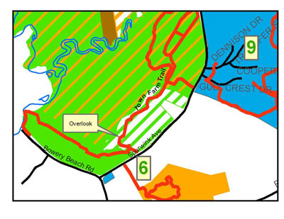
The Spurwink Trail skirts the edge of the Spurwink Marsh and the fields of the Town Farm. The trail is a loop that begins and ends at different locations along Spurwink Rd. The three main access points along Spurwink Ave are just south of the branch of the Spurwink River (across from the sewer treatment plant), at the cluster of trees extending from Spurwink Ave across the fields, and on the north side of Pollack Creek. The trail generally follows the edge of the mowed field, but at the southern end of the field, it slips into the woods and runs along the edge of the marsh. The reward for following this low lying section of trail is the view of the marsh as the trail rises to a lightly wooded point nestled between the marsh and the northern side of Pollack Creek. From the point, the path meanders along the creek back to Spurwink Ave, just before the guardrail. Trail users should be very respectful as as they pass along several colonial grave sites.
The trail surface is grassy in the field, but once you enter the woods can be muddy with exposed roots. The trail length is approximately 1 mile.
Click here for a complete description of the entire Greenbelt trail system, including trails description, maps and allowed uses.