(December 2023 - download map)
All of the trails depicted on this map are legally accessible to the public.
Trails not shown on this map may be located on private property and access to them is at the discretion of the property owner. When using public trails, please respect adjacent private property and remain on the trail.
Town trails are generally marked with a green "G" Greenbelt sign.

Please leave trails as you found them and carry out your trash. Please make sure your pets do not interfere with the enjoyment of other trail users and practice a "carry out" policy. Courteous use of trails will make it possible to expand the trail network throughout Cape Elizabeth.
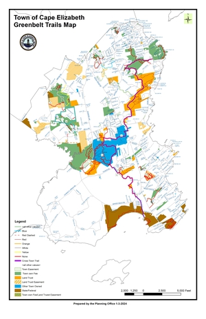
1. Stonegate Trail Length: 2.75 miles
Access: Shore Rd, across from Fort Williams Park, Dyer Pond Rd, Locksley Rd, Rock Crest Drive. The Loveitt Woods section located on the north end of the trail network.
Description: Wooded area including streams and wetlands with mild to moderate grade changes.
2. Hobstone Trail (CELT) Length: 0.5 miles
Access: The end of Hobstone Rd.
Description: Wooded area with frequent, moderate grade changes. This is a self-contained loop trail on dry land adjacent to wetlands.
3. Highlands Trail Length: 1 mile
Access: Pine Ridge Road, Broad Cove Rd and the Two Lights Trail system.
Description: Mostly dense scrub growth transitioning to woodland. Much of trail is directly adjacent to wetland, including a few ponds. Trail has gentle inclines with one 6' drop off.
4. Great Pond Trails Length: 1.5 miles
Access: Route 77 adjacent to Golden Ridge Ln, the end of Fenway Road, which connects to the boat racks and launch at Great Pond.
Description: The trail provides a varied experience of walking through fields, woodland and wetland marsh, and rock steps and boardwalk with a commanding overlook view of Great Pond.
NOTICE: Signage for the trailhead has been currently removed due to construction on Golden Ridge Lane. Once construction is complete, the signage will be reposted. 3/2022
5. Town Center Trail Length: 1 mile
Access: Route 77, access is located behind the Cape Elizabeth High School, Scott Dyer Rd, west of the entrance to Village Crossing, Starboard Drive.
Description: Most of the trail is located on top of a sewer easement and is maintained as a grassy surface. The trail provides plentiful views of the Spurwink Marsh, including from a bridge and boardwalk spanning the marsh, as well as woodland and wetland trails.
6. Runaway Farm Trail (CELT) Length: 0.4 miles
Access: Spurwink Ave, near the intersection with Route 77.
Description: The trail winds through high grasses and sparse woods, with moderate grade changes.
7. Town Farm Trail Length: 1.5 miles
Access: Spurwink Ave
Description: This trail begins at the edge of a field, winds through a wooded area, crosses over a bridge to a heavily vegetated wetland area. Grades are gentle to moderate. Trail includes colonial burial ground and connection to the Pollack Brook Pedestrian Bridge.
8. Dyer HutchinsonTrail (CELT) Length: 0.8 miles
Access: Sawyer Rd.
Description: This trail begins in a field and enters wooded and wetland areas. Grades are moderate.
9. Gullcrest Trails Length: 3.1 miles
Access: Entrances are located at the far end of the parking lot across from the Public Works Garage and the end of the paved area past the Public Works Garage and on Spurwink Ave, ' south of the Spurwink River.
Description: The trail skirts a field and enters a wooded wetland environment with moderate slopes and boardwalks.
10. Cross Hill Trails Length: 2.7 miles
Access: Wells Rd, Cross Hill Rd, Apple Tree Lane, Hawthorne Rd and Leighton Farms Rd. This trail network connects to Winnick Woods.
Description: Trails are predominantly wooded with both moderate and steep slopes, with at least one bridge crossing a wetland area.
11. Robinson Woods (CELT) Length: 1.6 miles
Access: Off Shore Road and Belfield Rd
Description: Wooded and hilly trails
12. Canterbury Trail Length: 1.1 miles
Access: Columbus Road, Mitchell Road via Wedgewood Road. (NO ACCESS from Ocean House Rd)
Description: Wooded and hilly trails with a boardwalk to cross wetland area.
13. Winnick Woods Length: 2.8 miles
Access: The Trailhead is located on Sawyer Rd and includes a small gravel parking lot and kiosk.
Description: This 71 acre parcel includes extensive woodlands, wetlands, a pond and a meadow. Grades on the trails can be steep and bridges and boardwalks have been constructed.
14. Whaleback Trail Length: 0.3 miles
Access: Access is from Whaleback Way and Route 77, although the Route 77 access is very steeply sloped.
Description: Whaleback is wooded and includes a stream and wetlands. Grades are moderate to very steep.
15. Dyer Woods Length: 0.6 miles
Access: Woodland Ave, Cliff Ave, Fernwood Rd, Blueberry Rd.
Description: Wooded with small pond.
16. Cottage Brook Trails Length: 0.6 miles
Access: Spurwink Ave, multiple points on Aster Ln
Description: Wooded trails with moderate hills and wetland with boardwalk crossings.
17. Turkey Hill Farm(CELT) Length: 0.5 miles
Access: Old Ocean House Rd
Description: Wooded trail
18. Pollack Brook Trail Length: 0.6 miles
Access: Spurwink Ave, Riverside Cemetery
Description: This trail connects to the Town Farm Trail and includes a pedestrian bridge across Pollack Brook and colonial burial grounds. The trail connects to the Riverside Cemetery gravel road network. On the western end of the cemetery, a trail extends to the Spurwink River and provides an overlook.
More information about conservation easements, including deeds for most properties, is available on our MapGeo GIS mapping service. (Select "Conservation Parcels" on thematic overlay menu)